Introduction
Blue Force Tracking (BFT) is a United States military term used to denote a GPS-enabled system that provides military commanders and forces with location information about friendly (and despite its name, also about hostile) military forces. In military symbology, the color blue is typically used to designate friendly forces while red is used for enemies, and green or yellow are used for neutral forces.
This brief discusses the applicability of BFT solutions in Homeland Security, and the components of a BFT solution.
The components of a BFT solution
A BFT system consist of a computer, used to display location information; a satellite terminal and satellite antenna, used to transmit location and other operational data; a Global Positioning System receiver (to determine its own position); command-and-control software (to send and receive orders, and many other operational support functions); and mapping software, usually in the form of a GIS, that plots the BFT device on a map.
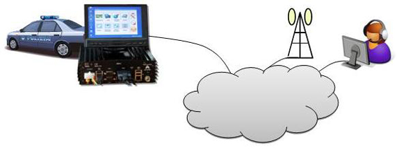
The system displays the location of the host vehicle on the computer’s terrain-map display, along with the locations of other platforms (friendly in blue, and enemy in red) in their respective locations. The BFT system can also be used to send and receive text and visual messages, and has a mechanism for reporting the locations of enemy forces and other battlefield conditions (for example, the location of mine fields, battlefield obstacles, bridges that are damaged, etc.).
The BFT solution allows a user to:
- Provide a Common Operational Picture (COP)
- Represent Blue-Force units on a map
- Generate Statistical Reports: speed, service times, …
- Process data from vehicle sensors
- Transmit/Receive messages
BFT and Homeland Security
BFT solutions are now frequently used in Homeland Security applications. The use-cases are as follows:
Border Surveillance System
A BFT module in a border surveillance system allows operators to track interceptors in real time and coordinate interception operations.
Critical Infrastructure Protection
Security personnel and assets are tagged to ensure that they follow the planned surveillance route, as well as to coordinate crisis-response activities.
Emergency Management System
Agencies that are entrusted with emergency management duties (police, fire, medical, utilities, etc.) can use BFT to coordinate response to emergencies, as well as to facilitate information exchange laterally.
Tactical Operations
In counter-terrorism and counter-insurgency campaigns, BFT can be used to track tactical units in real-time, and to allow command and control communications with the units.
Desiderata for a BFT solution
BFT solutions are not all developed on the same template: there are different feature-sets implemented by different vendors. However, users should insist on the following capabilities from a BFT solution:
- Real-time data synchronization
- Low-bandwidth network operation
- Remote configuration
- Intuitive and easy-to-use HMI (Human-Machine Interface)
- Support for mobile units sensor management
- Options for features such as ANPR, form-filling, etc.
Conclusion
Organisations looking into managing and optimizing surveillance manpower, and coordinating activities in complex surveillance set-ups, will benefit enormously from implementing a BFT solution.
Mistral offers the Amper C4ISR nemesis product line for Homeland Security needs in India. Amper’s nemesis BFT solution is targeted at organizations and agencies requiring real-time control over their security manpower resources, as well as those looking to increase the sophistication of their surveillance operation.
Amper is a leading provider of BFT solutions, worldwide, with over 25,000 users (tracked vehicles) of the application.